
South Fork Crow River
Introduction and Purpose
In 2022-2023, local partners with the South Fork Crow River Watershed developed the South Fork Crow River Watershed Comprehensive Watershed Management Plan (SFCRW CWMP) through the One Watershed One Plan (1W1P) program. The 1W1P program is administered by the Board of Water and Soil Resources (BWSR) through Minnesota Statutes§103B.801. This resulting plan is not a regulatory document. The plan instead focuses on voluntary conservation and provides a framework to guide watershed managers (local counties, soil and water conservation districts, and the watershed district) as they work to manage the watershed’s natural resources.
Plan Area
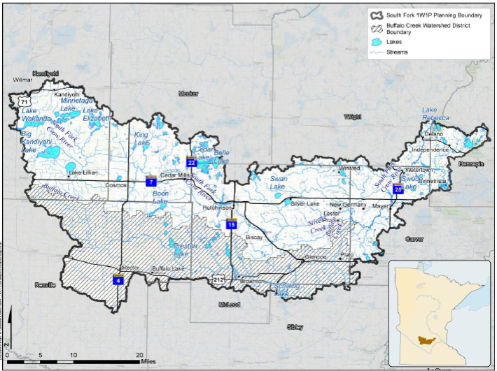
The South Fork Crow River Watershed (SFCRW) planning area is a predominately agricultural watershed in central Minnesota. The planning area is defined by Hydrologic Unit Code 8 watershed boundaries. The eastern side of the watershed extends into the seven county metropolitan area. Minnesota Statutes Chapter 103B.231 of the Metropolitan Surface Water Management Act requires metropolitan watershed districts and water management organizations to develop and adopt a watershed management plan. As such, the Pioneer-Sarah Creek and Carver County Watershed Management Organization (CCWMO) have Water Management Plans that overlaps with a portion of the SFCRW.
The watershed is 72 miles wide when measured between the cities of Independence and Willmar. The watershed is roughly 1,280 square miles and contains 179 lakes greater than 10 acres and over 1,420 perennial river and stream miles. It also crosses eight different county boundaries (Kandiyohi, Renville, Meeker, McLeod, Sibley, Wright, Carver, and Hennepin). The main river is the South Fork Crow River which flows from west to east and connects with the North Fork Crow River just upstream of Rockford, MN, before continuing to the Mississippi River as the Crow River.
Click here to see the South Fork Crow River Comprehensive Watershed Management Plan Tracker.
Click below to view the plan for the South Fork Crow River:
South Fork Crow River CWMP_Final.pdfSouth Fork Crow River CWMP Appendix_Final.pdf